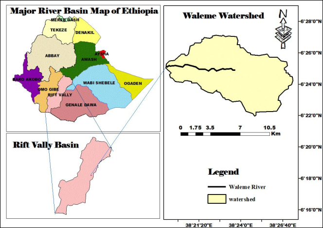
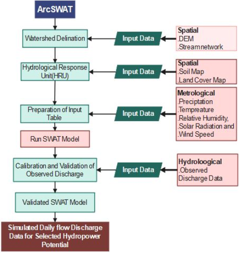
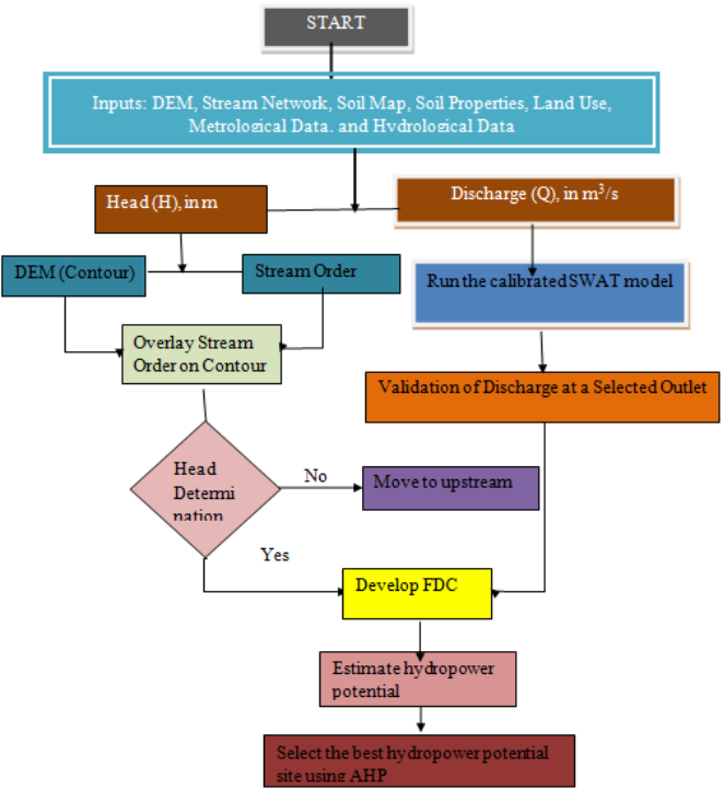
The research will focus on the assessment, feasibility, and hydropower potential estimation in the Gedeo zone Dilla Ethiopia with an analysis of the viability of the systems for rural community electrification. Waleme River Catchment is located in the Rift Valley basin, covering an area of around 80 km2 and It extends up to 30 km with a river basin This hydropower plant considers the reliability, sustainability, and environmental protections of supplying electricity to the village, particularly for remote communities where grid extension is not suitable. The hydropower renewable energy system will be the best solution for the off-grid areas. Due to international policy and the reduction of carbon dioxide emissions, the generation of electricity using renewable energy sources has become more significant. Currently, it is among the most intriguing and eco-friendly technology solutions. The hydropower potential of the site will be analyzed by measuring the gross head with the help of a Geographical Position System (GPS) and stream flow data analysis. The proposed research will be completed within two years with a total estimated budget of 363,075 ETB, by site surveying, data collection, and estimating the hydropower potential of Waleme River and finally the paper will be prepared for publication.
| Published in | International Journal of Environmental Protection and Policy (Volume 13, Issue 5) |
| DOI | 10.11648/j.ijepp.20251305.11 |
| Page(s) | 101-108 |
| Creative Commons |
This is an Open Access article, distributed under the terms of the Creative Commons Attribution 4.0 International License (http://creativecommons.org/licenses/by/4.0/), which permits unrestricted use, distribution and reproduction in any medium or format, provided the original work is properly cited. |
| Copyright |
Copyright © The Author(s), 2025. Published by Science Publishing Group |
Renewable Energy, Rural Electrification, Hydropower Potential, Waleme River
No | Data Types | Sources | Purpose |
|---|---|---|---|
1 | DEM | Alas Ka. S. F. https://search.asf.alaska.edu/ | 12.5*12.5 m resolution, used to delineate the Watershed, to analyze the spatial information |
2 | Land use/land cover raster map | Esri Portal (Global Land Cover) | 10*10 m resolution map of 2022 |
3 | Soil Data | Food and Agricultural Organization of the United Nations (FAO) | 1*1km (tentative) resolution map, soil layer attributes for each soil layer |
4 | Daily precipitation data | National Meteorological Service agency (NMSA) | Daily precipitation around the waleme watershed |
5 | Daily stream flow data | Ministry of Water, Irrigation, and Electricity (MoWIE) | Daily stream flow for the outlet of the watershed for calibration and validation |
7 | Daily weather data | National Meteorological Service agency (NMSA) | Daily wind speed, minimum and maximum temperature, and relative humidity |
DEM | Digital Elevation Model |
GIS | Geographic Information System |
GPS | Global Positioning System |
LULC | Land Use Land Cover |
MoWE | Ministry of Water and Energy |
| [1] | K. C. Surendra, D. Takara, A. G. Hashimoto, and S. K. Khanal, “Biogas as a sustainable energy source for developing countries: Opportunities and challenges,” Renew. Sustain. Energy Rev., vol. 31, no. November 2017, pp. 846–859, 2014, |
| [2] | F. Birol, “Power to the people,” IAEA Bull., vol. 46, no. 1, pp. 9–12, 2004. |
| [3] | A. Tilahun, “Assessment of Micro Hydro Power Potential of Selected Ethiopian Rivers-a Case Study in the North-West Part of the Country,” East African J. Energy, vol. 14, no. 5, pp. 670–679, 2011. |
| [4] | N. C. Office, “world bank 2010,” EPPO Bull., vol. 41, no. 3, pp. 467–476, 2011, |
| [5] | W. J. Klunne, “Small hydropower in Southern Africa - An overview of five countries in the region,” J. Energy South. Africa, vol. 24, no. 3, pp. 14–25, 2013, |
| [6] | B. C. Kusre, D. C. Baruah, P. K. Bordoloi, and S. C. Patra, “Assessment of hydropower potential using GIS and hydrological modeling technique in Kopili River basin in Assam (India),” Appl. Energy, vol. 87, no. 1, pp. 298–309, 2010, |
| [7] | E. Arthur et al., “Potential for small hydropower development in the Lower Pra River Basin, Ghana,” J. Hydrol. Reg. Stud., vol. 32, no. November, p. 100757, 2020, |
| [8] | A. N. Strahler, “Geological Society of America Bulletin DIMENSIONAL ANALYSIS APPLIED TO FLUVIALLY ERODED,” no. January 2009, 1958, |
| [9] | C. A. Kouadio et al., “Assessing the Hydropower Potential Using Hydrological Models and Geospatial Tools in the White Bandama Watershed (Côte d’Ivoire, West Africa),” Front. Water, vol. 4, no. March, pp. 1–14, 2022, |
| [10] | I. Bajracharya, “Assessment of run-of-river hydropower potential and power supply planning in Nepal using hydro resources,” Inst. für Energietechnik und Thermodyn., no. April, pp. 9–10, 2015. |
| [11] | S. G. Setegn, R. Srinivasan, and B. Dargahi, “Hydrological Modelling in the Lake Tana Basin, Ethiopia Using SWAT Model,” Open Hydrol. J., vol. 2, no. 1, pp. 49–62, 2008, |
| [12] | S. P. S. G. M. J. M. Cunderlik, “Hydraulic Model Selection for CFCAS projects Assessment of Water Resources Risk and Vulnerability to Changing Climatic Conditions,” coundruk, p. 282, 2003. |
| [13] | T. L. Saaty, “The analytic hierarchy process : planning, priority setting, resource allocation,” pp. 109–121, 1980. |
| [14] | K. Upadhyay, “Application of Analytical Hierarchy Process in Evaluation of Best Sewage Treatment Plant,” Int. J. Sci. Res., vol. 6, no. 6, pp. 2319–7064, 2015. |
| [15] | A. Genet and A. Bulti, “Assessment of Head for Hydropower Potential Using DEM, Google Earth, and GPS in the Furfuro Watershed, Ethiopia,” SSRN Electron. J., no. January, 2025, |
| [16] | A. Genet, A. Tadesse, T. Zelalem, T. Kifle, and A. Ejargew, “Prioritization Suitable Hydropower Potential Sites Along the Furfuro River, Ethiopia,” Int. J. Environ. Chem., vol. 9, no. 1, pp. 1–8, 2025, |
APA Style
Ejargew, A., Genet, A., Tegenu, M. T. (2025). Assessment of Hydropower Potential for Rural Electrification: A Case Study of the Waleme River. International Journal of Environmental Protection and Policy, 13(5), 101-108. https://doi.org/10.11648/j.ijepp.20251305.11
ACS Style
Ejargew, A.; Genet, A.; Tegenu, M. T. Assessment of Hydropower Potential for Rural Electrification: A Case Study of the Waleme River. Int. J. Environ. Prot. Policy 2025, 13(5), 101-108. doi: 10.11648/j.ijepp.20251305.11
AMA Style
Ejargew A, Genet A, Tegenu MT. Assessment of Hydropower Potential for Rural Electrification: A Case Study of the Waleme River. Int J Environ Prot Policy. 2025;13(5):101-108. doi: 10.11648/j.ijepp.20251305.11
@article{10.11648/j.ijepp.20251305.11,
  author = {Aynadis Ejargew and Amsayaw Genet and Moges Tariku Tegenu},
  title = {Assessment of Hydropower Potential for Rural Electrification: A Case Study of the Waleme River},
  journal = {International Journal of Environmental Protection and Policy},
  volume = {13},
  number = {5},
  pages = {101-108},
  doi = {10.11648/j.ijepp.20251305.11},
  url = {https://doi.org/10.11648/j.ijepp.20251305.11},
  eprint = {https://article.sciencepublishinggroup.com/pdf/10.11648.j.ijepp.20251305.11},
  abstract = {The research will focus on the assessment, feasibility, and hydropower potential estimation in the Gedeo zone Dilla Ethiopia with an analysis of the viability of the systems for rural community electrification. Waleme River Catchment is located in the Rift Valley basin, covering an area of around 80 km2 and It extends up to 30 km with a river basin This hydropower plant considers the reliability, sustainability, and environmental protections of supplying electricity to the village, particularly for remote communities where grid extension is not suitable. The hydropower renewable energy system will be the best solution for the off-grid areas. Due to international policy and the reduction of carbon dioxide emissions, the generation of electricity using renewable energy sources has become more significant. Currently, it is among the most intriguing and eco-friendly technology solutions. The hydropower potential of the site will be analyzed by measuring the gross head with the help of a Geographical Position System (GPS) and stream flow data analysis. The proposed research will be completed within two years with a total estimated budget of 363,075 ETB, by site surveying, data collection, and estimating the hydropower potential of Waleme River and finally the paper will be prepared for publication.},
 year = {2025}
}
TY  - JOUR
T1  - Assessment of Hydropower Potential for Rural Electrification: A Case Study of the Waleme River
AU  - Aynadis Ejargew
AU  - Amsayaw Genet
AU  - Moges Tariku Tegenu
Y1  - 2025/10/09
PY  - 2025
N1  - https://doi.org/10.11648/j.ijepp.20251305.11
DO  - 10.11648/j.ijepp.20251305.11
T2  - International Journal of Environmental Protection and Policy
JF  - International Journal of Environmental Protection and Policy
JO  - International Journal of Environmental Protection and Policy
SP  - 101
EP  - 108
PB  - Science Publishing Group
SN  - 2330-7536
UR  - https://doi.org/10.11648/j.ijepp.20251305.11
AB  - The research will focus on the assessment, feasibility, and hydropower potential estimation in the Gedeo zone Dilla Ethiopia with an analysis of the viability of the systems for rural community electrification. Waleme River Catchment is located in the Rift Valley basin, covering an area of around 80 km2 and It extends up to 30 km with a river basin This hydropower plant considers the reliability, sustainability, and environmental protections of supplying electricity to the village, particularly for remote communities where grid extension is not suitable. The hydropower renewable energy system will be the best solution for the off-grid areas. Due to international policy and the reduction of carbon dioxide emissions, the generation of electricity using renewable energy sources has become more significant. Currently, it is among the most intriguing and eco-friendly technology solutions. The hydropower potential of the site will be analyzed by measuring the gross head with the help of a Geographical Position System (GPS) and stream flow data analysis. The proposed research will be completed within two years with a total estimated budget of 363,075 ETB, by site surveying, data collection, and estimating the hydropower potential of Waleme River and finally the paper will be prepared for publication.
VL  - 13
IS  - 5
ER  -
Department of Water Resource Engineering, Dilla University, Dilla, Ethiopia
Department of Hydraulic Engineering, Wolkite University, Wolkite, Ethiopia
Department of Hydraulic Engineering, Wolkite University, Wolkite, Ethiopia